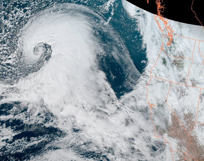
California declared a state of emergency Wednesday as a powerful storm generated 45-foot waves out at sea, dropped soaking rain on already saturated ground, and prompted warnings of floods and mudslides.
The storm’s impacts will ramp up during the afternoon and the more than 8 million people who live in the San Francisco Bay Area should limit travel, the regional National Weather Service office warned. Earlier in the day, California Gov. Gavin Newsom authorized state National Guard units to support disaster response as a massive storm pummeled much of the state’s coastline.
Fire and rescue equipment and personnel have been prepositioned in areas deemed most likely to experience severe flooding and mudflows.
GRAPHICS:‘Rivers in the sky’: Graphics show atmospheric river soaking California’s Bay Area
“If you’ve still got power, it’s a good idea to charge your cellphone, computers and tablets now while you can,” said National Weather Service meteorologist Cynthia Palmer in the agency’s San Francisco area office. If the power goes out, having access to timely information about the storm – and something to watch – will be useful, she said.
The storm is termed a “bomb cyclone” because it is expected to be marked by a quick drop in atmospheric pressure resulting in a high-intensity storm.
“All told it’s about a 30-hour event from start to finish,” said Rick Canepa, a meteorologist with the National Weather Service’s San Francisco office. “The rain won’t be done until Thursday afternoon or early evening.”
Severe weather could drop 10 or more inches of rain in some parts of Northern California over the next week, forecasters say. Wednesday’s storm was expected to knock down trees, cause widespread flooding, wash out roads, cause hillsides to collapse, slow airports and potentially lead to the “loss of human life,” the National Weather Service said.
But officials warn even then the danger isn’t over. Forecasters are watching other systems out at sea that could also hit the region with more precipitation.
Meanwhile, California wasn’t the only place facing severe weather on Wednesday. A possible tornado touched down near Montgomery, Alabama, early Wednesday. There were no deaths but the twister damaged more than 50 homes.
Flood-related deaths confirmed in Sacramento; motorists rescued
Two more bodies were found Wednesday after flooding in a rural part of south Sacramento County, authorities said, bringing the death toll from the atmospheric river storm on New Year’s Eve to three.
The third body was found in a vehicle that was submerged in water , said Sgt. Amar Gandhi, a Sacramento County Sheriff’s Office spokesman.
The victim had not been identified and there was no additional information about the incident, Gandhi said Wednesday night.
During the morning, California Highway Patrol officers found the body of a woman while recovering vehicles that got stuck due to flooding.
On Sunday, authorities discovered the body of a man inside a submerged vehicle. Gandhi said rescue efforts in Sacramento County are ongoing.
Elsewhere across Northern California communities, several motorists were rescued from flooded roads and fallen trees.
The San Francisco Fire Department rescued a family Wednesday night after fallen trees on a city road trapped the family.
California residents face outages
With heavy rain saturating the ground and strong winds, trees are more likely to fall and can cause widespread power outages, according to Karla Nemeth, director of the California Department of Water Resources.
Officials and power companies warned residents to prepare for possible outages due to the storm by creating emergency kits and keeping essential devices charged.
Nearly 178,000 homes and businesses were in the dark Wednesday night, according to PowerOutage.us, which tracks outages. Most outages were reported on the north coast of the state.
Evacuations ordered in coastal cities
Officials in Santa Cruz and Santa Barbara issued evacuation orders Wednesday as the huge storm puts the coastal areas at high risk due to potential mudslides and flooding.
Mandatory evacuation orders were issued for those living in burn scar areas in Santa Barbara County due to potential flooding and debris flows, Santa Barbara County Sheriff Bill Brown announced during a Wednesday news conference.
The Santa Cruz County Sheriff’s Office issued numerous evacuation orders for southern parts of the county throughout Wednesday due to concerns over potential flooding and debris flow from storm conditions.
Flight disruptions amid powerful storm
With its high winds and heavy rains, the storm is already causing flight disruptions in the Bay Area with more anticipated to come as the peak approaches.
As of Wednesday afternoon, San Francisco International Airport has experienced 74 flight cancellations, accounting for 8% of all flights.
About 191 flights have been delayed by an average of 35 minutes, according to Doug Yakel, a public information officer for the airport. “Delays and cancellations are a result of both the reduced ceilings and winds,” he told USA TODAY.
“In regards to general airport operations here at OAK, our operations team is prepared,” a spokesperson for Oakland International Airport told USA TODAY. Passengers with flights to and from Oakland are strongly encouraged to check with their airline through their mobile app or website for updates on their flights.
Travel waivers for flights disrupted by California’s “bomb cyclone”:
- Southwest Airlines is offering free rebooking for flights scheduled for Wednesday, for flights to and from Oakland, Sacramento, San Francisco, and San Jose. The rebooking must have the same city pairs and travel dates within 14 days of the original travel date.
- On Wednesday night, Delta Air Lines issued a travel waiver for flights scheduled on Thursday and Friday to or from San Francisco, Oakland, Sacramento, San Jose, and Fresno. The fare difference will be waived when the rebooked travel takes place on or before Jan. 8.Residents brace for floodsIn San Francisco, customers at Papenhausen Hardware were most worried about flooding, said store co-owner Karl Aguilar.
“Last week a fair amount of people were focused on the roofs – small leaks, windows, things like that,’’ Aguilar said. “There was a point where it transitioned and people became much more concerned with flooding mitigation. This particular storm, it’s all flood mitigation.’’
A few doors to the east, Grace Daryanani at Bulls Head restaurant has sandbags and wet/dry vacuum cleaners at the ready. Her space has flooded in big storms before but she’s hoping a new outdoor dining area might divert some of the water.
“Maybe that will help,” she said.
Wind gusts as high as 80 mphForecasters warned of flood threats and issued high wind warnings in the lead-up to the storm. The National Weather Service in the Bay Area delivered a rare admonition saying the coming “brutal” storm system “needs to be taken seriously.”
“Honestly, the biggest story right now is the winds,” said Palmer. Coastal areas could be hit with winds in the 40 to 50 mph range, while some mountain areas could get gusts as high as 80 mph.
Flooding and landslides likelyBecause the ground was already saturated with the more than 5 inches of rain that fell on New Year’s Eve, Wednesday’s storm could cause severe problems and damage in some areas.
“The main concern is the smaller watersheds and steep slopes. So mudslides, shallow landslides and urban and small creek flooding could get quite significant for a period of time on Wednesday night in some locations,” said Daniel Swain, a climatologist at the University of California, Los Angeles.
Severe weather, possible tornadoes in South
The South, too, was being hit with intense weather Wednesday. Heavy rains, flash floods and severe weather were seen in a swath across Florida, Georgia, North and South Carolina.
A possible tornado touched down in east Montgomery, Alabama at 3:14 a.m. on Wednesday.
Rodney Penn, who was home when the storm hit, said a fallen tree limb broke out the windows in his wife’s car but there was no structural damage to his apartment.
“It literally sounded like there were a thousand baseball bats hitting the side of the house at the same time,” Penn said.
In South Carolina, five counties were under a tornado watch Wednesday.
Heavy rain in California not an end to drought in West
The extreme drought conditions California has struggled under are helping avert some possible flooding because many of the state’s larger reservoirs are still quite low, said Swain.
“They have a lot of headroom right now to absorb a lot of water,” he said.
The state finds itself in the middle of a flood emergency even as it’s in the middle of a drought emergency, Karla Nemeth, director of the California Department of Water Resources said during a news conference Wednesday.
“A lot of our trees are stressed after three years of intensive drought, the ground is saturated and there is a significant chance of downed trees that will create significant problems, potentially flooding problems, potentially power problems,” she said.
While the rains are likely to alleviate the short-term drought in Northern California along the coast, they will do little in terms of bringing drought relief to the West as a whole.
“It won’t really help move the needle in the Colorado basin but it certainly will in central and northern California,” Swain said.
More water is on the way
There are two more possible storms also out in the Pacific, one that could arrive late Friday and run into Sunday and then another possible storm that could arrive Tuesday, Canepa said.
Both could bring higher-than-normal rain levels through the middle of January.
There’s a wide range of uncertainty for next week, ranging from a couple of additional moderate storms which wouldn’t cause too many problems to one or possibly more atmospheric river events.
What’s an atmospheric river?
The storm, the second of three or possibly four headed toward the California coast, is coming from across the Pacific ocean. It’s what’s known as an atmospheric river or, to use the term more common a few years ago, a Pineapple Express because it originates over Hawaii.
These storms bring heavy rainfall and occur when a line of warm, moist air flows from near the islands across the Pacific Ocean to the West Coast.
When it reaches the cooler air over the western landmass, the water vapor falls as heavy rain. Atmospheric rivers are long, flowing regions of the atmosphere that carry water vapor across a swath of sky 250 to 375 miles wide. They can be more than 1,000 miles long – and can carry more water than the Mississippi River.
Contributing: Dinah Voyles Pulver and Kathleen Wong, USA TODAY; Evan Mealins and Alex Gladden, Montgomery Advertiser; Hannah Workman, The Record

Source: usatoday.com


